 Berlin WW2 Tours
Topography of Terror: Visiting the Documentation Centre in Berlin
The Topography of Terror is the documentation centre on the former site of the Gestapo headquarters, the SS leadership, the SD and the Reich Security Main Office in Berlin. Admission is free and the centre is open daily from 10:00 to 20:00, so a visit costs nothing but time. This page explains what stood on the block at Niederkirchnerstraße 8, what the three permanent exhibitions cover, how to get there from S Anhalter Bahnhof or S+U Potsdamer Platz, and how a guided walk fits around it. The centre documents the perpetrators, and it treats that task with care. The bookable tours are compared on World War II tours in Berlin.
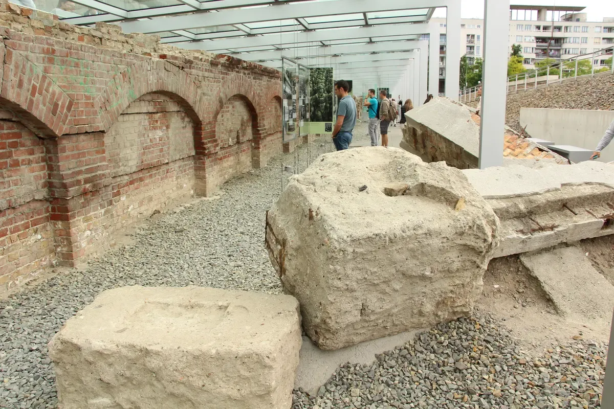
The open-air exhibition on the former Gestapo grounds, with excavated cellar walls and the information panels. Photo: Fred Romero from Paris, France, CC BY 2.0, via Wikimedia Commons
Quick answer Topography of Terror in brief
The Topography of Terror is a free documentation centre in Berlin at Niederkirchnerstraße 8, on the site where the Gestapo, the SS, the SD and the Reich Security Main Office had their headquarters from 1933 to 1945. It is open daily 10:00 to 20:00 and admission costs nothing.
Key takeaways
- Admission is free and no ticket is needed. The visit section lists hours, stations and closures.
- The site holds three permanent exhibitions plus a 200 m Wall section. Details in what you see.
- Several walking tours stop at the site and leave you free to enter the exhibition afterwards.
- Planning a full day of sites? The Berlin WW2 tours homepage compares guided options and do-it-yourself routes.
Topography of Terror: Tickets, Hours and Getting There
The centre is one of the easiest major memorial sites in Berlin to plan around, because entry is free and opening hours are long. The table pulls the practical details from the official centre information and one secondary listing.
Practical Details at a Glance
The address is Niederkirchnerstraße 8, 10963 Berlin. The documentation centre is open daily from 10:00 to 20:00, and the outdoor areas stay accessible until dusk, 20:00 at the latest. Admission is free. The nearest stations are S Anhalter Bahnhof and S+U Potsdamer Platz, and Potsdamer Platz is about 791 m, roughly 10.6 minutes, on foot. The centre offers guided tours, workshops and audio guides, and it provides information in sign language and easy-to-read language.
During the Long Night of Museums, a valid event ticket is needed for entry after 18:00. On ordinary days no ticket is required at all. If you want a guided experience of the wider government quarter rather than the centre alone, the 2-hour Third Reich and Cold War walk passes the site.
| Item | Detail |
|---|---|
| Admission | Free |
| Hours | Daily 10:00 to 20:00 |
| Outdoor area | Open until dusk, 20:00 at the latest |
| Closures | Not listed on the official centre page |
| Address | Niederkirchnerstraße 8, 10963 Berlin |
| Stations | S Anhalter Bahnhof, S+U Potsdamer Platz |
| Time needed | Not stated by the centre |
| Guided tours | Offered by the centre, plus workshops and audio guides |
| Accessibility | The centre states it can accommodate accessible visits, and offers sign language and easy-to-read information |
| Contact | 030 254509-0, info@topographie.de |
Do You Need Tickets
No. Admission to the Topography of Terror documentation centre is free, so there is nothing to buy in advance. The one exception named by the centre is the Long Night of Museums, when a valid ticket for that event is required for entry after 18:00. Audio guides are offered at the centre, and no audio guide price is stated, so ask on site.
If you want a guide for the surrounding streets rather than the exhibition rooms, the historian-led Hitler's Berlin walk lists the Topography of Terror among its stops and costs $51.
Getting There and How Long to Plan
Take the S-Bahn to Anhalter Bahnhof or the S-Bahn and U-Bahn to Potsdamer Platz. A single AB ticket costs €4 (reduced €2.50) and is valid for 2 hours, which covers either approach from central Berlin. Walking distances from nearby sites are useful for planning a route on foot: the centre sits about 791 m and roughly 10.6 minutes from Potsdamer Platz, about 564 m and 7.5 minutes from Checkpoint Charlie, and about 843 m and 11.2 minutes from the Führerbunker site. The Berlin Story Bunker museum near Anhalter Bahnhof is about 625 m away, around 8.3 minutes on foot.
The centre does not state a recommended visit length. With an indoor exhibition of more than 800 square metres, a 15-station outdoor tour of the grounds and a second exhibition on Berlin under the Nazi regime, a visit can fill well over an hour, and you should not plan to rush it. Free admission means you can split a visit across two days if that suits you.
Access and Facilities
The centre states that it can accommodate accessible visits and offers information in sign language and easy-to-read language. Guided tours and workshops are offered by the centre, and the library on site holds about 25,000 volumes along with roughly 120 current periodicals for anyone who wants to read further. For other indoor memorial museums in the city, including hours and admission figures, see the guide to WW2 museums in Berlin.
Sources: Topographie des Terrors, Time Out Berlin
What Stood on This Site
The name Topography of Terror refers to the lay of the land: the physical traces of the buildings where the Nazi regime organised persecution. Understanding what stood here explains why the documentation centre exists at this address.
The Nazi Headquarters Block, 1933 to 1945
From 1933 to 1945 the block on former Prinz-Albrecht-Straße housed the Gestapo headquarters, the SS leadership, the SD and, from 1939, the Reich Security Main Office. The Gestapo basement held prison cells. The permanent exhibition today documents the institutions themselves and the people who ran them, because the perpetrators worked here in ordinary offices on an ordinary street.
After 1945: Rubble, Wall and a Long Debate
The buildings were demolished in the 1950s, after which the site served as a bumper-car track and a dumping ground. From 1961 to 1989 the Berlin Wall ran along the south side of the site, which lay on the boundary between the American and Soviet occupation sectors. The idea of a memorial on the site dates to 1978.
The first exhibition opened in 1987 for Berlin's 750th anniversary, and excavation uncovered the cellar of the Gestapo headquarters, including the former basement prison cells. A foundation for the site was established in 1992.
A Failed Building and the Centre of 2010
The road to the current building was not smooth. Peter Zumthor won the 1993 competition for a documentation centre with a design likened to the skeleton of a barracks, but the original contractor went insolvent and about €13.9 million was spent before the Zumthor building was abandoned. The unfinished concrete structure was demolished in 2004.
A new competition was launched in June 2005 and Ursula Wilms of Heinle, Wischer und Partner won it in January 2006, working with landscape architect Heinz W. Hallmann. The present documentation centre has a facade of metal lamellae and 3,500 square metres of floor space, built with a budget of about €15 million plus €5-9 million for the interior and the outdoor site. It was officially opened on 6 May 2010 with Federal President Horst Köhler and opened to the public on 7 May 2010.
Sources: Wikipedia: Topography of Terror, Topographie des Terrors
Topography of Terror
The documentation centre on the former Gestapo and SS headquarters site, presented by the IHRA. Third-party video by TheIHRA. This site did not shoot it and has no relationship with the creator.
What You See Inside and Outside
The centre runs three permanent exhibitions, an outdoor tour of the grounds with 15 stations, and changing special exhibitions. The Wall section on Niederkirchnerstraße belongs to the same visit.
The Permanent Indoor Exhibition
The indoor permanent exhibition covers the Gestapo, the SS and the Reich Security Main Office on Wilhelmstraße and Prinz-Albrecht-Straße. It occupies more than 800 square metres of the 2010 building and documents the institutions, their personnel and their crimes. This is the core of a Topography of Terror museum visit, and it is presented soberly.
The exhibition names the perpetrators and describes the machinery of persecution they operated from this exact block, which makes the location part of the exhibition rather than just its container.
The Outdoor Tour of the Grounds
The site includes a 15-station outdoor tour titled 'The historical site', which walks you across the excavated grounds. The excavation uncovered the cellar of the Gestapo headquarters with its former basement prison cells. The outdoor areas are open until dusk, 20:00 at the latest.
Allow time to read the station panels rather than treating the grounds as a shortcut between the Wall section and the exhibition building.
Berlin 1933-1945
A second permanent exhibition, 'Berlin 1933-1945', covers propaganda and terror in the capital itself. It complements the main exhibition by narrowing the focus to the capital. Together the three give the site its full shape, and all three are covered by the same free admission.
The Wall Section on Niederkirchnerstraße
A 200 m section of the Berlin Wall stands on Niederkirchnerstraße beside the site. It is described as the longest surviving stretch of the outer Wall. The Wall ran along the south side of the grounds from 1961 to 1989, so the segment is not a relocated fragment but part of the site's own history.
It connects the Nazi story of the block with the division of the city.
Special Exhibitions
The centre announces a special exhibition on the Holocaust titled 'The Holocaust - What Did Germans Know?' It is announced to run from late March to late January, so check the centre's own pages for exact dates and any accompanying programme before your visit. Special exhibitions are included in the free admission. Beyond exhibitions, the centre offers guided tours, workshops and audio guides, and its library holds about 25,000 volumes for readers who want to go further.
Nearby Sites That Belong to the Same Story
The site sits close to other places that interpret the Nazi period and the city's division. Anhalter Bahnhof, about 600 m southeast of Potsdamer Platz, was the departure point for 9,600 Jews deported to Theresienstadt in 116 trains, and a section of its façade remains. For the underground side of the city's history, the Berlin underground tours guide covers bunker visits elsewhere in the city.
Hitler's bunker site, a residential car park today, is covered separately in the guide to Hitler's bunker, about 843 m and 11.2 minutes away on foot.
Sources: Topographie des Terrors, Wikipedia: Topography of Terror
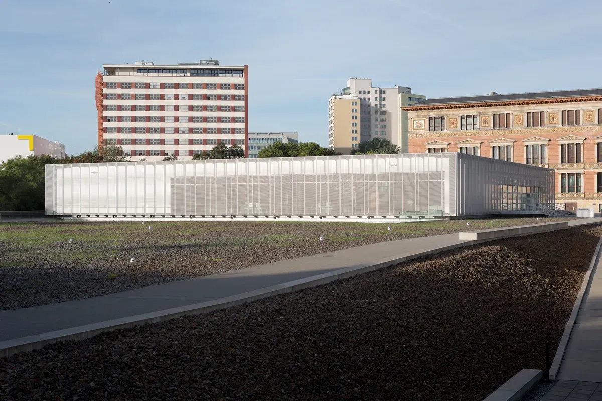
The documentation centre beside the open exhibition ground. Photo: Josef Streichholz, CC BY-SA 4.0, via Wikimedia Commons
Seeing It on a Walking Tour
The Topography of Terror appears on the route of several bookable walking tours of the Nazi government quarter. Be clear about what they include: the tours stop outside, and the exhibition itself is free to enter on your own afterwards.
Which Tours Stop at the Site
The 2-hour Third Reich and Cold War walk runs from the Brandenburg Gate through the Reichstag, the Soviet War Memorial, Hitler's Bunker site and the Topography of Terror to the Berlin Wall and Checkpoint Charlie. It costs $27 and is the most reviewed walk of its kind on this site, with 9,890 reviews and a rating of 4.9. The half-day Third Reich walk spends 4 hours on the Anhalter Bahnhof ruins, the former Gestapo and SS headquarters, Hitler's bunker site and the Reichstag for $22.91, and it requires your own AB zone transport ticket for a short train ride.
For a slower and smaller format, the historian-led Hitler's Berlin walk caps groups at 10 guests, covers nine sites including the Topography of Terror, and costs $51 for 2.5 hours. The private Third Reich tour includes the site in a 3 to 4-hour itinerary with hotel pickup, listed by the booking platform at $194.12 per person, so check at booking which option and party size that figure covers. Full details of all of these are in the World War II tours in Berlin on the homepage.
What the Tours Do and Do Not Include
None of these walks includes entry to the indoor exhibitions, and the historian-led tour states this explicitly, listing indoor museum exhibitions as not included because the tour is outdoors. That is not a shortchange. The outdoor grounds, the 15 stations and the Wall section are exactly what a guide can interpret best, and the documentation centre costs nothing to enter on your own.
A common pattern is to take a walking tour that ends near the site and then go inside the centre afterwards, at your own pace, for free. If you want indoor depth with guidance, the centre's own guided tours and audio guides are the option the centre itself offers.
Frequently Asked Questions
Is the Topography of Terror free?
Yes. Admission to the documentation centre is free, and the outdoor areas and the Wall section on Niederkirchnerstraße are free as well. The only ticketed case named by the centre is the Long Night of Museums, when a valid event ticket is needed after 18:00. If you want a guided walk that passes the site, the 2-hour Third Reich and Cold War tour costs $27.
What are the Topography of Terror opening hours?
The centre is open daily from 10:00 to 20:00, and the outdoor areas stay accessible until dusk, 20:00 at the latest. The official page does not list closure days, so confirm around public holidays via the centre at 030 254509-0. Practical details are collected in the visit section above.
How long do people spend at the Topography of Terror?
The centre does not state a recommended visit length. What is documented is the scale: an indoor permanent exhibition of more than 800 square metres, a second exhibition called 'Berlin 1933-1945', a 15-station outdoor tour and a 200 m Wall section. Free admission means you can return. A structured alternative is a guided walking tour that covers the outdoor site in its route.
What does Topography of Terror mean?
The name refers to the physical topography of the site itself: the excavated traces of the buildings where the Gestapo, the SS, the SD and the Reich Security Main Office were headquartered from 1933 to 1945 on Prinz-Albrecht-Straße. The terror was organised in ordinary offices on this block. The history section traces the buildings from their construction to the 2010 centre.
Do I need Topography of Terror tickets in advance?
No. There is no admission charge and no advance booking for the permanent exhibitions, so searches for Topography of Terror tickets generally lead nowhere useful. Guided tours, workshops and audio guides are offered by the centre itself, with contact details in the visit section.
Is the Topography of Terror worth visiting?
It is one of the most significant memorial sites in Berlin because it documents the perpetrators at the place where they worked, with free admission and long daily hours from 10:00 to 20:00. It is not entertaining, and it is not meant to be. It is a documentation centre, and it rewards time and attention. Combining it with a guided walk of the government quarter adds the wider street context, and Berlin WW2 tours compares the options.